SETE CIDADES (Sao Miguel, Azores, Portugal)
12.2 Power places
Names
– Ilhas de bruma – Islands of Haze
In the 12th century, the Arabian seafarer Edrisi became the first to give the islands this name, marking them as “Ilhas de bruma” on his chart because thick fog (“Bruma”) obscured his view.
– Ilhas dos Açores – Islands of the Hawks
In 1427, Portuguese explorers believed that they saw hawks circling in the sky; this turned out to be incorrect — these “Azores” were buzzards. But the name stuck.
– Sete Cidades – Seven Cities
Near the following power place in the caldera of the same name, there lies a farming village with the name of Sete Cidades. But there is no true city anywhere on the island (see Legends, page 527).
Geomancy
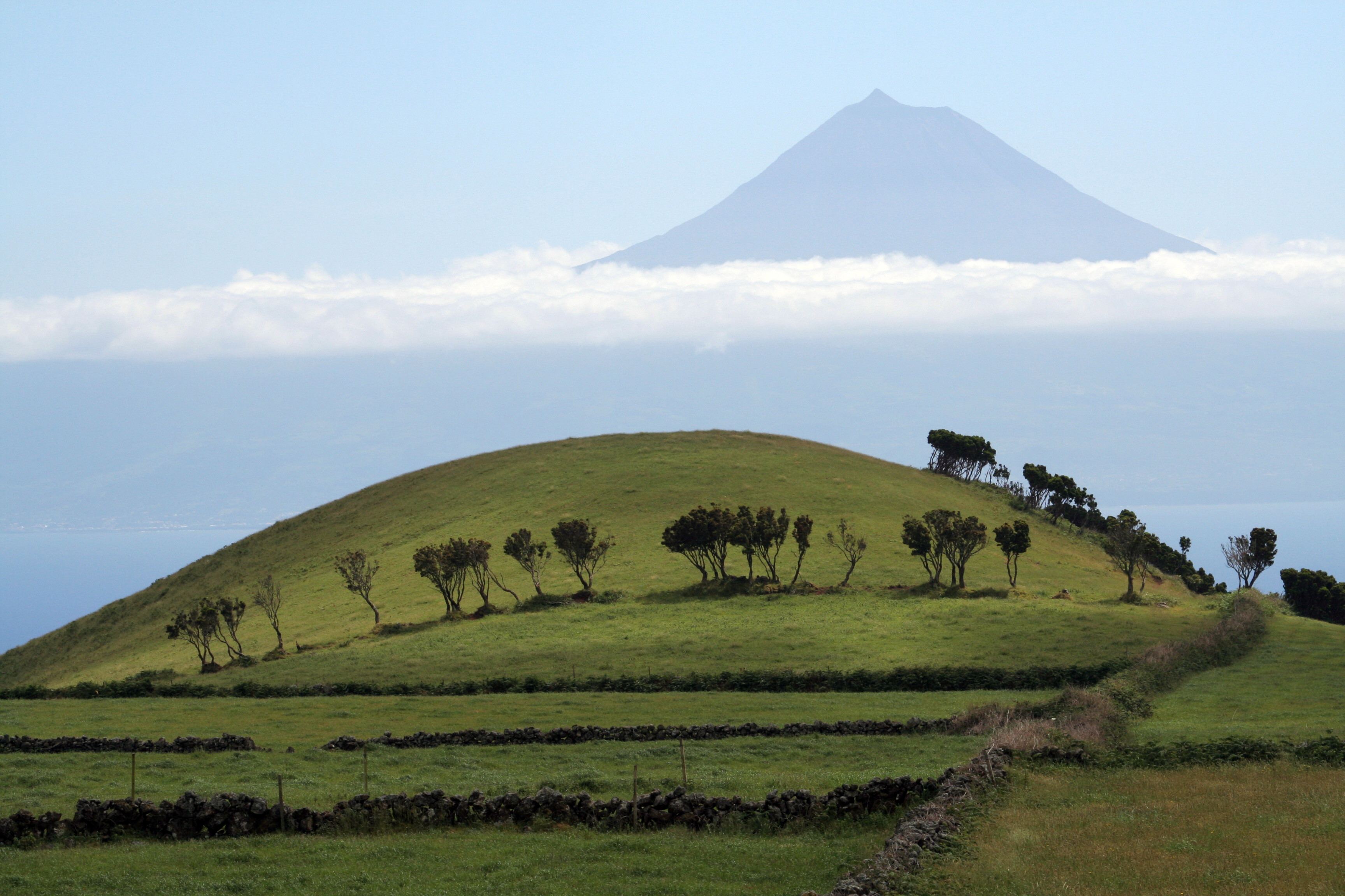
The lush volcanic islands, far out in the Atlantic, are forcefully elemental, but at the same time light and airy because of the winds and the quickly changing weather. The islands are still almost pure in their energy and aura, especially in the bays, on the volcanoes and in the crater lakes. Like their fauna and flora, they are extremely multifaceted, almost as much as the Galapagos Islands. The vegetation combines the most beautiful plants and trees of Europe and America, lending extraordinary energy and a unique aura in this interaction of elements and energies.
Power point
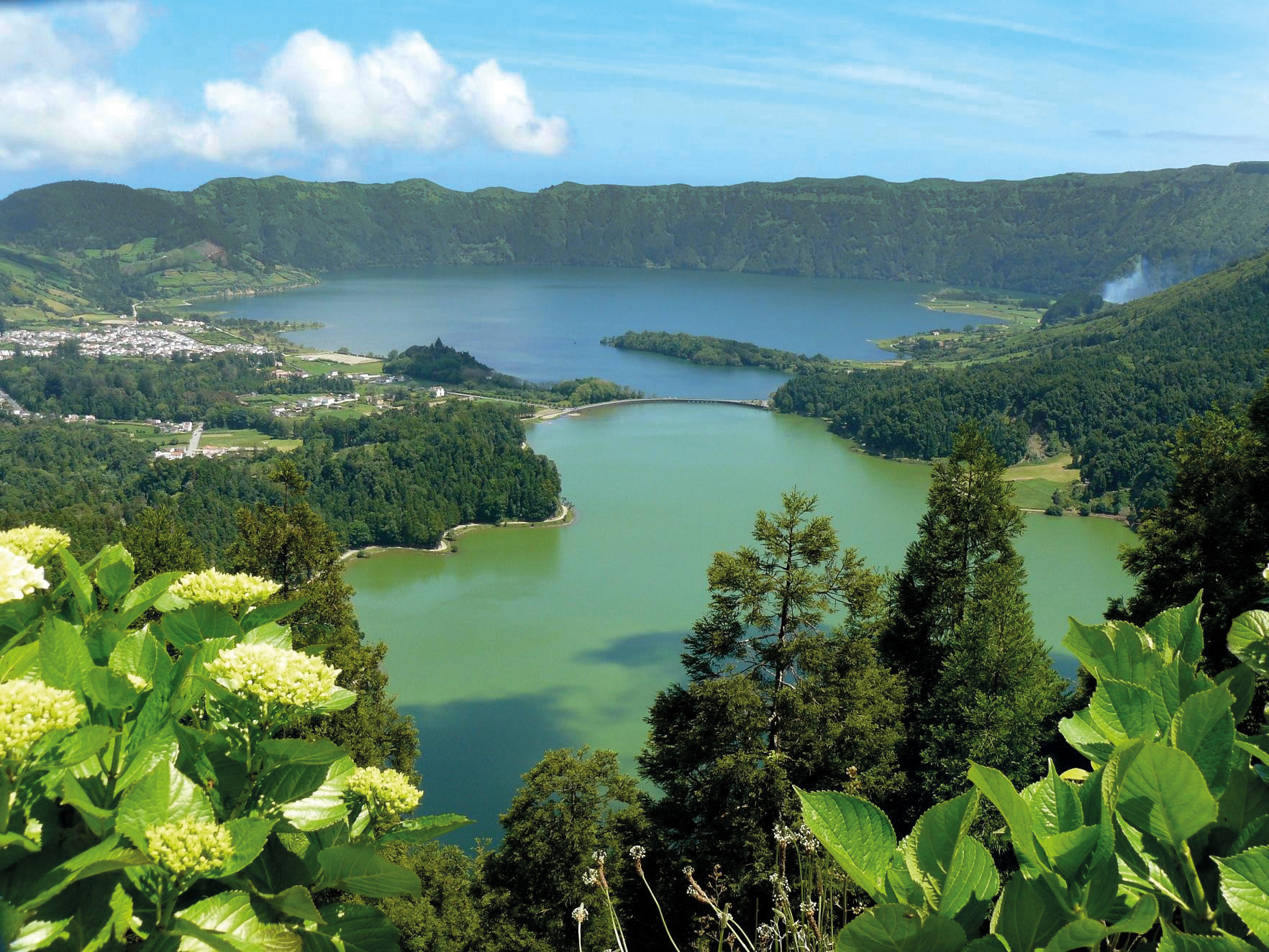
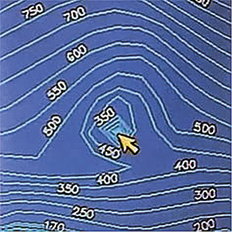
The actual power point is in the Sete Cidades volcano, surrounded by a towering 300 meters tall crater wall, between two crater lakes that stretch more than 5 km from northwest to southeast and are 1-2 km wide.
The well-known lookout point of Vista do Rei at the edge of the crater is 550 meters above the ocean. Its name, which means “King’s View”, refers to the penultimate Portuguese King Carlos I, who was led to this spot on his visit to the island in 1901. However, most visitors find themselves among clouds of fog and see almost nothing. On my trip in July 2008, I was very lucky to have mostly good weather interrupted only by the obligatory storms.
Lagoa Verde takes its name from the greenish shimmer it emits when the sunlight falls on it; this effect is caused by the reflection of the wooded crater edge. Behind it, accessible over a narrow bridge over the crater’s edge, lies the Lagoa Azul. Its name comes from the fact that it glows blue because of its depth. After heavy rains, both lakes are almost equally murky green; they have no outlet and their levels used to vary so greatly that they often flooded the adjacent farming village of Sete Cidades in the winter (several stilt houses from the last century in the old part of the village are a reminder of this).
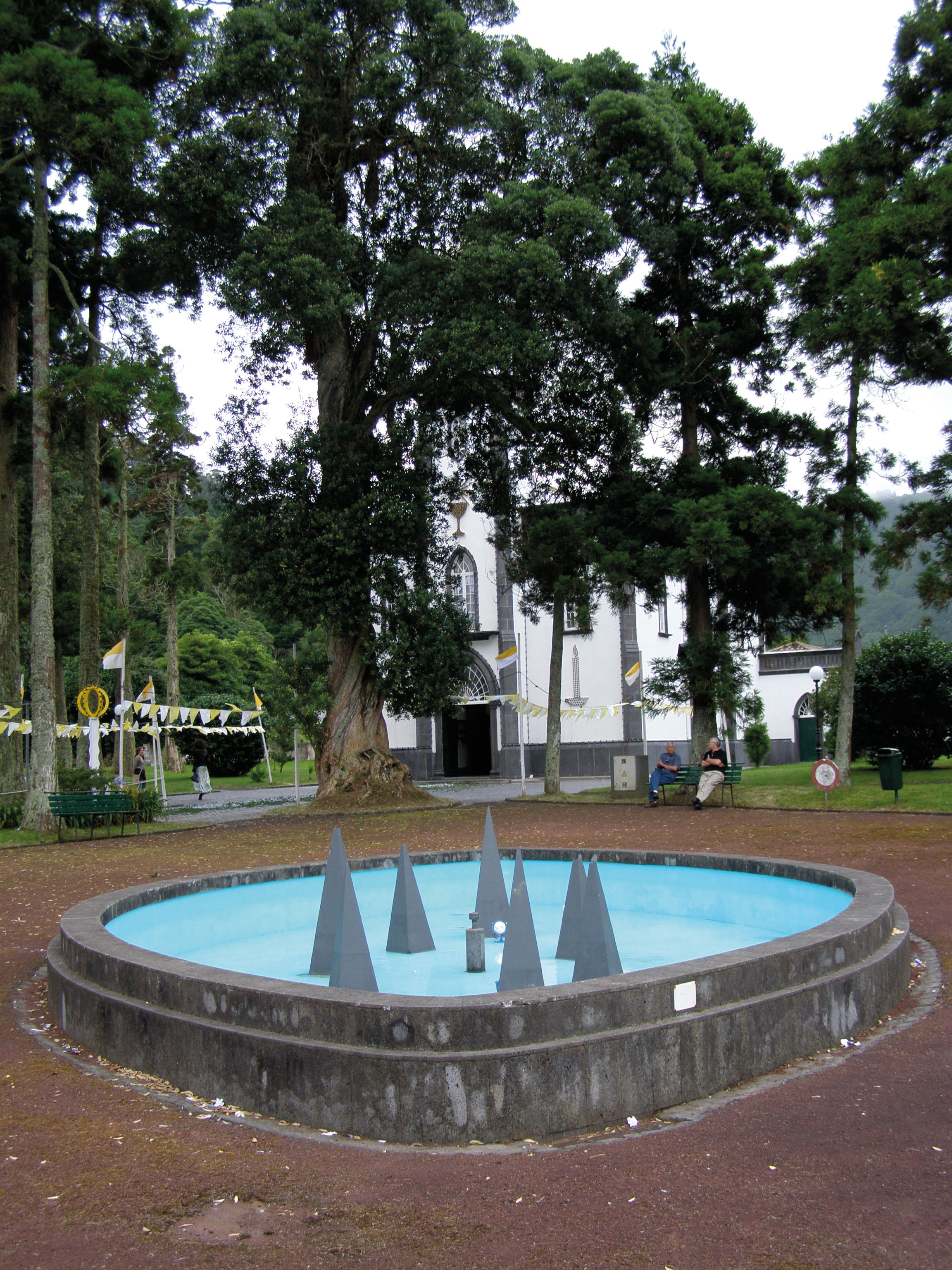
The small neogothic church is dedicated to Saint Nicholas and is the destination of an annual procession across pyramids and symbols made of flowers (see page 528). Next to the church is a well that tantalizingly depicts the seven cities as seven pyramids. We will return to this point.
Note:
The volcano bears the same name as the village and the huge caldera which contains the lakes in smaller craters is the largest in the Azores with a diameter of over 12 km. It is thought to have formed in the middle of the 15th century as the first settlers began to log the forested slopes of the 1,200-meters-high volcano. A huge eruption tore through the mountain and caused the crater to collapse. This is indicated by the reports made by the seafarer Gonçalo Velho Cabral during his voyage to Sao Miguel in 1444. He used the volcano as a key landmark and reported that it suddenly disappeared. His ship was forced to struggle through heavy seas clogged with tree trunks while stones and ash rained down from the sky, which was lit by glowing clouds of ash, while gaseous vapors polluted the air.
– Corresponds to: solar plexus chakra, power
– Color: golden yellow
– Dominant elements: earth and fire
– Corresponding place: Ollantaytambo, Peru
12.3 Main structures
So far, no megalithic complexes have been found, although the Azores are the most likely location for the sunken continent of Atlantis.
Pyramid off Sao Miguel
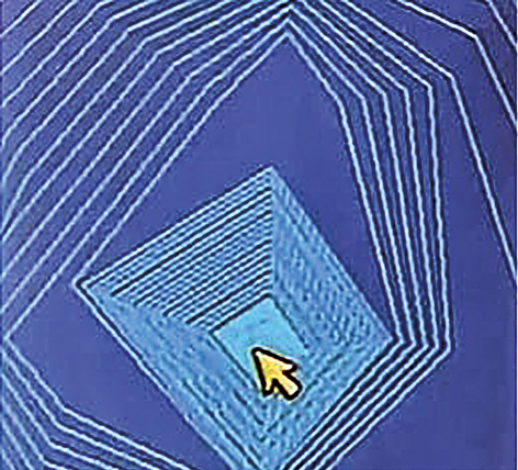
However, at the end of September 2013, when I had completed the rough draft of this book and was busy revising it, sensational news arrived: “A pyramid has been discovered in the Azores!” Could this finally be the proof that there really was an Atlantis in the Atlantic? Sailor and fisherman Diocleciano Smith had discovered the pyramid between the islands of Terceira and São Miguel at a depth of 100 meters on his sonar and knew immediately that this geometric structure could not be a natural elevation. Smith said in a televised interview:
“The pyramid is perfectly shaped and also appears to be oriented precisely according to the cardinal points.” (12.2 – Smith)
He was referring to the four points of the compass. This is further evidence that the pyramid is a megalithic complex. Subsequent calculations revealed it to be 60 meters high with a base area of 8,000 m2. The ocean is about 100 meters deep at that point, which means that the apex of the pyramid is 40 meters below the ocean’s surface. But the pyramid actually has no apex; the sonar image shows a platform, much like those on the South American pyramids.
Smith said that he officially submitted the coordinates to the Portuguese Cultural Ministry in the spring of 2013 and the Portuguese government says that the find is being analyzed by its navy.
There has since been much speculation by Atlantis researchers and historians that the find is a pyramid from the Atlantis of legend which was mentioned in a historical document for the first time by the Greek philosopher Plato. Experts have been arguing about whether Atlantis actually existed or was only inspired by other civilizations of the time (see the chapter on Giza, page 111).
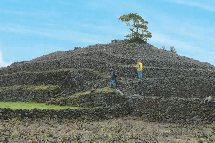
Pyramids on Pico
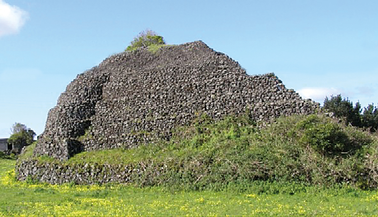
I already knew there were stone pyramids in the Azores and had seen one on my trip there in 2008. Unfortunately, it was in very poor condition, since, as has occurred at many other places, it had been plundered for building materials, because the local population was not aware of its significance. But I was obviously in the wrong place; on August 28, 2013, a report appeared in the “Portuguese American Journal” about the 140 pyramids that had been documented by the Portuguese association for archaeological research (APIA) in recent years. They are all on the island of Pico in the Madelana region and called “maroiços” by the natives.
These pyramids are up to 13 meters high and built of roughly hewn stones. Most have the classical four-cornered shape, but some are three-cornered and others are round. The report also said that the analysis of the Azorean pyramids confirmed the hypothesis that the island had been settled thousands of years before the arrival of the first Portuguese ships. It mentions Phoenicians or even a previous culture!
The researchers are just as amazed by the number of pyramids and their distribution over many locations: in fields, in woods, on cliffs and in lava craters. They believe that the structures were built according to a plan and with a precise astronomical orientation that, among other things, accounted for the summer solstice. They interpret the constellation to be a votive site that was of course immediately associated with rituals and burials. But there is no indication of whether human remains have actually been found.
This means that true research on the many pyramids on Pico has only just begun, and that this leaves plenty of room for speculation. It appears to have gone unnoticed – at least, nothing was included in the report – that these stone pyramids are surprisingly similar to those in the Canary Islands, Sicily, North Africa and Madagascar. In the interest of comparison, we will therefore examine the pyramids in the Canary Islands, which Thor Heyerdahl researched and for which he identified the possible builders. All these structures are indications of the ancient knowledge of pyramid engineering in the Atlantic region.
This is just a small excerpt from the book GAIA LEGACY.
12. SETE CIDADES, Sao Miguel (Portugal)
12.1 Landscape 501
– Geography 501
– Geology 504
– Climate 506
– Vegetation 507
12.2 Power places 510
– Names 510
– Geomancy 510
– Power point 511
12.3 Structures 512
– Main structures 512
– Subterranean structures 518
– Other structures in the region 519
– Temple structures 519
12.4 History 520
– Historical History 520
– Finds 522
– Prehistoric history 524
– Builders and peoples 525
– Original purpose 526
– Legends and myths 527
12.5 Spirit 528
– Religions and deities 528
– Spirituality and Transmissions 530