OLLANTAYTAMBO (Peru)
5.2 Power place
Names
Like Mount Shasta, there are various versions for how the name Ollantaytambo originated:
– In the language of the Quechua, the name comes from “Ollanta”, a well-known Inca general, and the word “tambo”, a Spanish derivation of the Quechua word “tampu”, or city. Thus it means “city of Ollanta”.
– In the language of the Aymara, Ollantaytambo is pronounced “ulla-nta-wi ” and means “place to look downwards”. Here, the word „tambo“ for city was also added later.
– Locals correspondingly describe Ollantaytambo as “place of my God” or “storehouse of my God”.
Geomancy
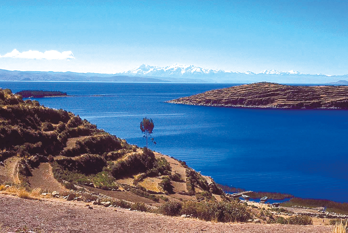
There is probably a reason why the extensive valley system through which the river Vilcanota flows from Pisac to Machu Picchu is known as the “Sacred Valley of the Incas”.
The Urubamba Valley itself, where the megalithic complex of Ollantaytambo can be found, is called “Sacred Valley”.
It lies within the Andes Mountains‘ stony eastern foothills between the two mountain ranges of Vilcanota and Vilcabamba, and is very fertile because of the Urubamba River, a constant level of humidity and the moderate climate.
The place has a subtle, light energy that provides a clearing and uplifting effect, particularly in the area of the old core complex from prehistoric times.
Power point
The city of the same name, Ollantaytambo, is located at an altitude of nearly 2,800 meters in southern Peru, in the Urubamba Province (20 km linear distance from the main town of Urubamba and about 60 km northwest of Cuzco.)
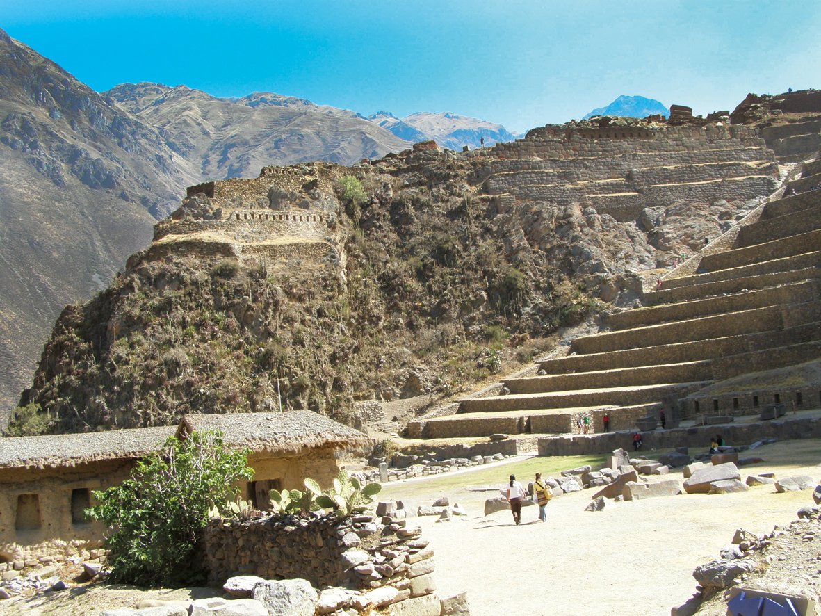
The megalithic complex rises from the foothills in front of the town, a center and true power place on the earth‘s grid, surrounded by Inca complexes.
As we already know from other places, it is important here to distinguish between the megalithic buildings (sun temple, king‘s chamber and water temples) and buildings added and complemented later by cultures which honored, maintained, and expanded the old sites (here, the Incas).
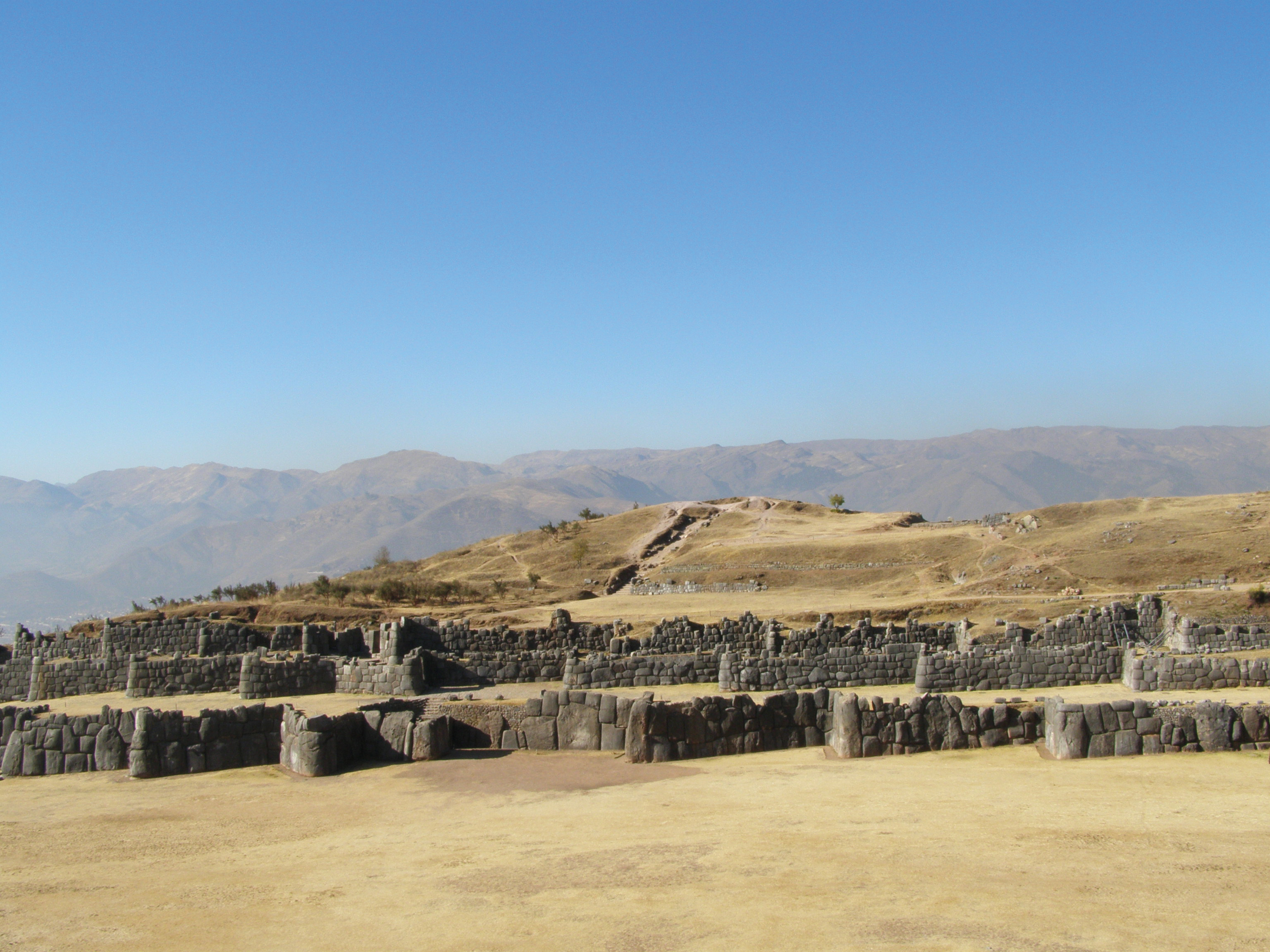
The official historiography attributes the entire complex of structures, called “fortaleza” (fortress) because of its unusually strong walls, to the Incas. Indeed, the site is located at a strategic spot, commanding the valley. This is probably also a reason why the Incas expanded the original sacred site to create a huge complex. Below the core complexes, there are buildings for administration, agriculture, and the military immediately adjacent to the sacred buildings, which, along with the terraces and the narrow alleyways of the town‘s prehistoric core, are almost in their original condition.
Located above the core complex on the plateau are simple houses, fortified walls and the “mausoleum” carved into the rock. From there, a steep path leads up to the Intiwatana, the “place to which the sun is bound”. It was used for astronomy, for the observation of the sun, moon, planets and stars, according to which the Incas determined the proper times for sowing and harvesting.
– Corresponds to the solar plexus chakra, power
– Color: golden yellow
– Dominating elements: earth and fire
– Corresponding place: Sete Cidades, Azoren
5.3 Main structures
Manaracay – The King‘s Chamber
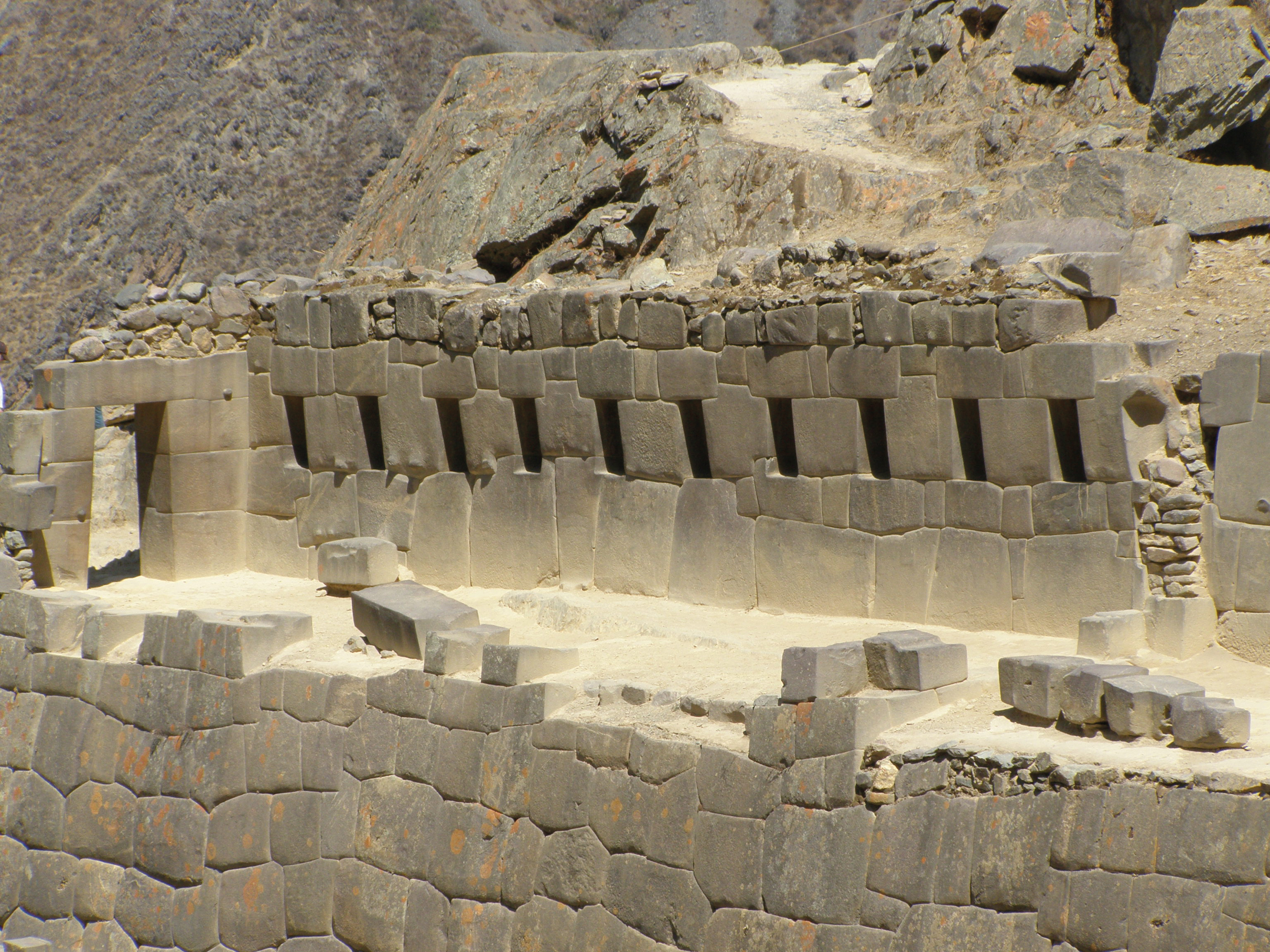
Through the terraces, exactly 200 steps lead up to the sacred area and end in front of the large megalithic gate, the entrance to the Manaracay.
It is necessary to pass through this room to reach the most holy place. Depending on the source, it is called “king‘s chamber”, “fore-temple” or “temple of the ten alcoves” because ten alcoves were elaborately built into the walls in a polygonal construction. Some sources say that statues of gods were placed in those alcoves, while others lean towards explanations that lie in the magical numbers or the holy geometry, analogous to the units of ten, eleven, or twelve, which we also found at the three megalithic pyramids in Egypt.
Subterranean structures
So far, no subterranean structures have been found or substantiated.
Temple structures
Here, the monoliths on the “temple hill” are really the main structures and form the megalithic core of the complex. The temple sector encompasses the sun temple‘s monoliths to the south, the middle sector, and the northern sector of the dead (the Incas‘ tombs). We read from many historians that many buildings were never completed; often there is only one side, or the interior is incomplete. However, it is obvious that later occupants destroyed the sun temple, because the smaller stones that were part of the complex can be found all over the terraces, the piazza rearrangements at the bottom of the hill, and even in the church and the town hall.
The sun temple with its six monoliths
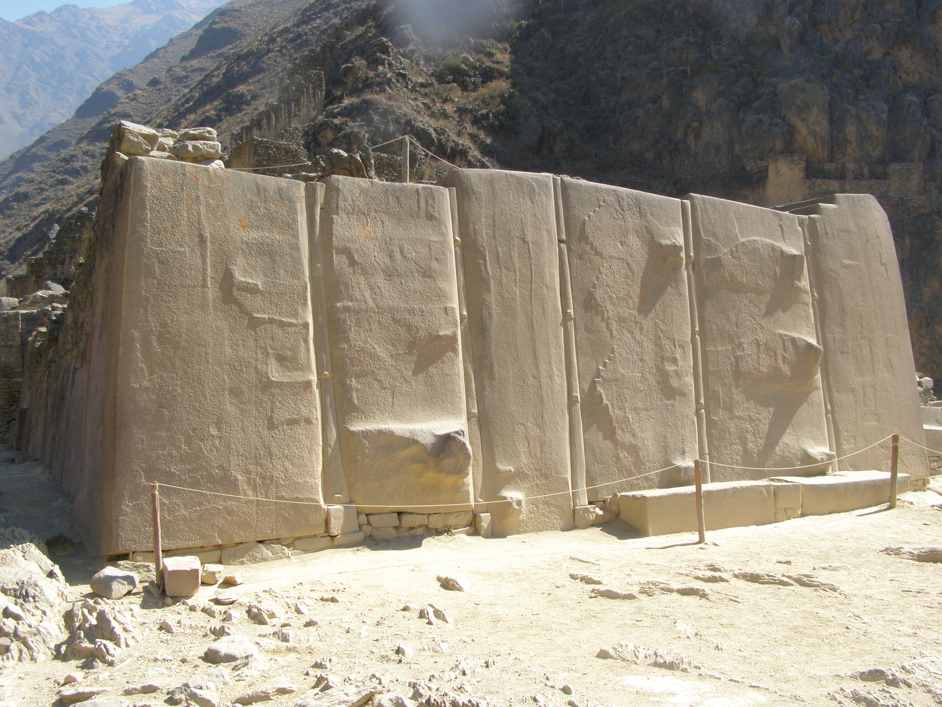
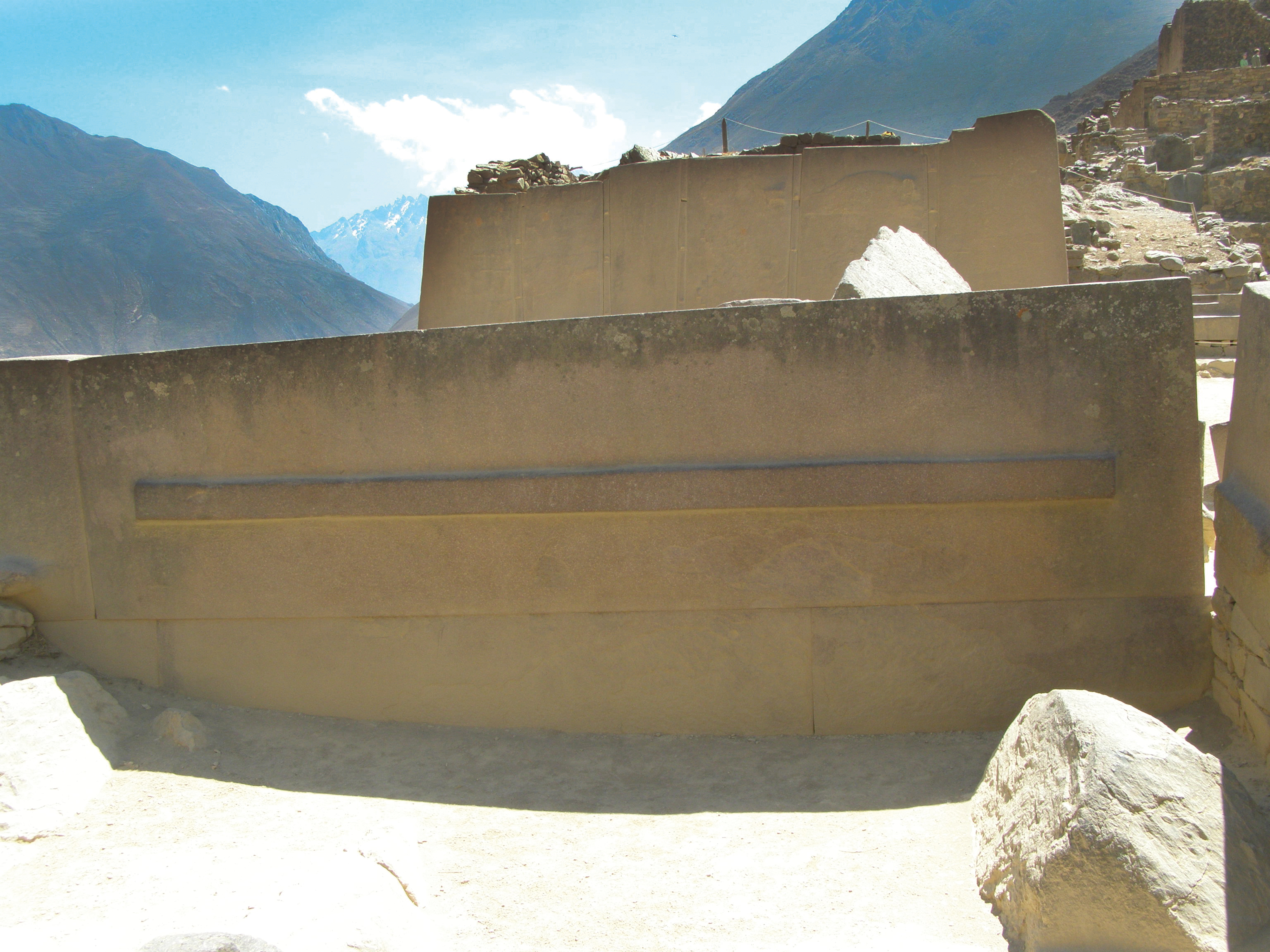
The core of the megalithic complex is located nearly at the top of the plateau and is called “sun temple”, “royal house of the sun” or “light castle”.
To the left of the sun temple are several additional walls made of large granite blocks; these walls are followed by the actual main wall made of six enormous and artfully polished monoliths of red granite (like those in Giza and Tiahuanaco). They are between 3.4 and 4 m high, 1.3 to 2.2 m wide, 0.7 to 2 m thick and weigh 40 to 50 tons each. With their enormous size and weight, it remains unclear to this day how the builder separated those huge stone blocks in the steeply sloping stone quarry on the other side of the valley and transported them across the valley, and back up the steep hill to this place – all without using technological devices, wheels, or pulleys. It is also unclear why the monoliths were not assembled smoothly, as is usual for Inca constructions, but joined with long stone joints that fit exactly on both sides, which is unique and involves immense construction challenges. Equally unusual are the straight lines that were cast in bronze in T-shaped joints to hold the wall together.
The only other site known to exhibit this method of construction is Tiahuanaco, so archaeologists assume that builders were brought from there and from Pachacútec to work as forced laborers on this wall. They do not consider the possibility that the same architects and builders might have been involved in building all these megalithic structures. They argue that the final work must be attributed to the Inca, with the smoothly polished connections and exteriors and the three symbols carved out of monoliths, which is incorrect because, without doubt, those symbols represent the three states of the Andean world handed down from Tiahuanaco: the “Hanan Pacha” (sky, spirit), the “Kay Pacha” (earth, matter) and the “Ukhu Pacha” (underworld, underground).
It is therefore more likely that the builders were the same or that the symbols were handed down in both cultures. Furthermore, those symbols – and the bronze castings – might simply have been added by the Incas afterwards, just as the Pharaonic dynasties in Giza arranged their statues and applied other signs (such as the only hieroglyphics next to the entrance of the small pyramid, Mykerinos).
This is just a small excerpt from the book GAIA LEGACY.
5. OLLANTAYTAMBO (Peru)
5.1 Landscape 225
– Geography 225
– Geology 227
– Climate 228
– Vegetation 229
5.2 Power place 230
– Names 230
– Geomancy 230
– Power point 231
5.3 Structures 232
– Main structures 232
– Subterranean structures 232
– Temple structures 232
– Other buildings in the region 236
5.4 History 249
– Traditional history 249
– Finds 257
– Prehistoric History 257
– Builders and peoples 257
– Original purpose 258
– Legends and myths 259
5.5 Spirit 261
– Religions and deities 261
– Spirituality and transmissions 265